Introduction:
GPS full form: In an age of technology and connectivity One innovation is a beacon for navigation and exploration: the Global Positioning System (GPS). From helping travelers navigate through uncharted terrain to allowing accuracy in scientific studies, GPS has revolutionized the method we navigate and comprehend our world. In this blog, we set out on a journey that will unravel the mysteries of GPS by exploring its history function, its functions, and its profound impact on our society today.
1. The Genesis of GPS:
Created as a product of the United States Department of Defense, GPS traces its origins back to the Cold War era when the need for precise tracking and positioning capabilities was essential. It was launched in 1973. GPS initially was designed for military use but was later made accessible to the general public, turning it into a universal instrument for navigation and services that use location.
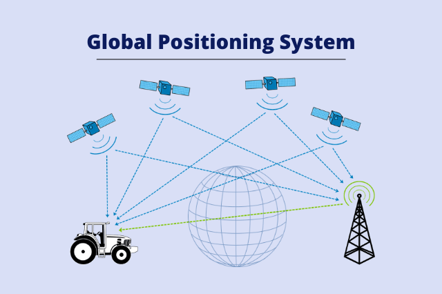
2. How GPS Works:
In its fundamentals, GPS operates through a constellation of satellites orbiting around the Earth that emit signals that are picked up by GPS receivers located on the ground. By triangulating signals of multiple satellites GPS users can pinpoint their precise location, speed and time with incredible precision. This technique is based on precise timing and sophisticated algorithmic techniques to determine distances based upon the time taken for signals to be transferred between satellites and receivers.
3. Applications of GPS:
Navigation The GPS is now an essential tool for navigation across a variety of domains, including maritime navigation, aviation as well as road transportation as well as outdoor recreational. From helping pilots navigate airplanes to helping drivers navigate difficult routes, GPS enhances safety and efficiency of transportation.
mapping and surveying GPS technology allows the creation of maps with high-detail and precise surveys by finding the coordinates of geographical landmarks and features. It is utilized in urban planning and land surveying, cartography and environmental monitoring.
Precision Agriculture in agriculture GPS helps in the implementation of precise farming practices by supplying farmers with real-time information on the condition of their soil, the health of their crops, and machine guidance. This permits efficient use of resources and higher yields of crops while minimizing environmental impacts.
4. Beyond Earth:
Although GPS mostly operates on the surface of Earth but its applications go beyond the terrestrial sphere of navigation. GPS technology is used for research in space, satellite communications and research in science which allows for exact positioning as well as synchronization for telescopes, spacecrafts as well as scientific instruments.
5. Future Directions:
With technology continuing to advance as technology advances, it is expected that the next generation of GPS promises more precision, reliability and adaptability. The development new satellite technologies advanced signal processing algorithms, and integration with new technologies such as artificial intelligence and autonomous vehicles are expected to further increase GPS’s capabilities. GPS in the coming years.
Conclusion:
In an era where accuracy and precision is paramount, GPS serves as a beacon of light, shining a spotlight on our routes and expanding the possibilities of discovery and exploration. From the bottom of the ocean, to the far reaches of space, GPS empowers us to navigate safely, explore with curiosity, and comprehend the world around us with unmatched accuracy. In the spirit of celebrating the transformational impact of GPS on our society today We should be embracing the opportunities it offers and continue to tap into its potential to benefit of humanity.


